Company Insight
Sponsored by Geotab
Geotab Ace
The AI tool that lets fleet managers talk to their data.
Main image credit:
As mine fleets grow more complex and data-heavy, Geotab is helping Fleet Managers cut through the noise. Enter Geotab Ace, the intuitive AI assistant that lets users ask plain-language questions and get instant, actionable insights. Whether it’s predicting battery failures, flagging risky driver behaviour or identifying the worst fuel offenders, Ace transforms how fleet teams interact with data, making powerful insights accessible to everyone, not just data experts.

Chris Martin, Senior Manager of Solutions Engineering APAC, Geotab.
We spoke with Chris Martin, Senior Manager of Solutions Engineering APAC, about how Geotab’s smart technology is shaping what fleet intelligence looks like on modern mine sites.
How has Geotab Ace changed the way that Fleet Managers interact with the data in their day to day, given that mining is such a sort of complex project?
We've recently done surveys with customers using Ace to get their feedback on whether it's adding value and overwhelmingly the responses were “Yes”. A Fleet Manager can think, “I’ve got a fuel bill that I'm not comfortable with.”, and ask Ace, “What are my top 10 vehicles in terms of fuel consumption for the last month?”, and in that moment they just want to ask the question and get the answer on their phone, laptop, or device.
How does Ace ensure that users are not only getting answers, but they also understand how those answers or insights are generated?
In this context, where people are going to make decisions, we need to make sure we're giving reliable and consistent information. The quality of the source data is paramount. We pride ourselves on the caliber of that data. We collect it from multiple sources, and factor in many variables.
We're not just using your average LLM. We're using specific models trained just on Geotab data sets. All we need Ace to do is understand that, and that's exactly how it's being trained. It's grounded in data with the common types of questions and themes that Fleet Managers ask. It will provide a figure or a list, but also explain exactly what it's done, and if there’s a miscommunication, it’s easy enough to revise the question.
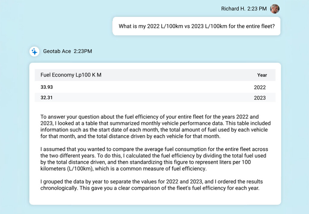
Geotab Ace enables Fleet Managers to use plain language to gather instant, accurate insights about their fleet.
With 5G enabling real-time transmission of large volumes of data, what kinds of operational decisions are now possible for Fleet Managers that weren’t before?
The most common way is the vast increase in the volume of data that can be transmitted, which is exciting. But the other IoT perspective is low power, broad coverage networks. It’s not just about high-volume data, but also low power, cost-effective connectivity. If we can avoid sending someone out to check a fuel tank level or a pump in remote operations, and simply have IoT products connected to a control room, that's beneficial.
For high-data transmission, video telematics is exciting, especially for fatigue management. When there’s an event, you could get a short video of exactly what happened. Do we have a problem with driver fatigue? That context is useful, and video content.
Caption. Credit:
You mentioned IoT and the benefits of connected devices. That’s become a significant benefit for maintenance especially. How is Geotab leveraging this connectivity?
Collecting data like fault codes is helpful, we also have our predictive battery failure capability. With 5 million vehicles connected globally, we collect cranking voltage data every time a motor starts. We've trained an AI model using historical data and service records to spot patterns. It's data too complex for humans, but AI can do it. We can now predict battery failure with high confidence and help fleets reduce downtime, cut costs, and improve efficiency.
Another focus for Geotab is leveraging AI to assist with predictive driver risk. What capabilities is that bringing for Geotab and safety teams?
Traditionally, the industry’s done safety scorecards— harsh braking, cornering, speeding... we know those affect safety. But the thresholds have been arbitrary. We’ve trained a model using collision data, so if certain driving dynamics keep showing up before a crash, the model learns that. Now we can say, for example, a driver has a 10% chance of a collision in the next 100,000 km.
We can parse the data by vehicle type, age groups, geography, weather, and more. Or benchmark against peers. If one driver’s risk jumps 50% this month, maybe something’s going on at home, or something else is affecting their performance. It’s a far more actionable and accurate way to manage driver safety.
Given the sensitivity of fleet data, how does Geotab’s approach to AI-driven querying and insights maintain privacy and security?
Geotab takes data privacy seriously, starting from a clear principle: the customer owns their data, and it’s our job to protect it. That mindset is deeply embedded in the company’s culture. We never send customer data to third-party large language models. When we do use external tools, it’s only to help interpret the user's question—never to process or access the actual data. All querying and insights stay within Geotab’s systems. We could talk at length about our technology, the AES-256 encryption, and the FIPS 140-3 certifications, but more importantly, we believe in treating data with care because it’s the right thing to do. That belief runs throughout the company, from leadership to every team member.
For further information visit www.geotab.com/au/ace/