Company Insight
Sponsored by Emesent
Mapping new prosperity: Emesent’s Hovermap enables safer mining productivity
Standfirst...
Main image credit:
Emesent is a world-leader in drone autonomy, LiDAR mapping, and related 3D data processing. Our vision is to help clients make better operational decisions about challenging and seemingly unreachable places through the autonomous digitalization of these harsh environments.
How Emesent is Deploying Technological Solutions for Sustainable Mining Practices on the Path to Net Zero Emissions
The path to achieving net zero is intertwined with technological advancements reshaping how companies navigate safety, profitability, and sustainability challenges. With a surge in investment, innovation is accelerating, particularly in critical minerals essential for renewable energy and electronic devices. Projections indicate a staggering increase in demand for minerals like lithium and copper, necessitating advancements in mining workflows to meet safety and sustainability goals. Technological capabilities, including robotics, AI, and data analytics, promise to revolutionize exploration and extraction processes, unlocking previously inaccessible resources.
Since 2018, Emesent has pioneered innovative advancements in drone autonomy and data analytics, enhancing operational efficiency and safety while unlocking previously untapped resources. The first to deploy autonomous drones in underground stope mapping, Emesent not only ensures a safer and more efficient workflow but also reshapes the landscape of underground exploration, revolutionizing our perception of inaccessible terrains. Proudly Australian-designed and built, Emesent embodies ingenuity and resilience, leading the charge towards a more sustainable future with a dedicated team of over 100 experts and a global network of 50 distributors.
Unlocking the Unreachable
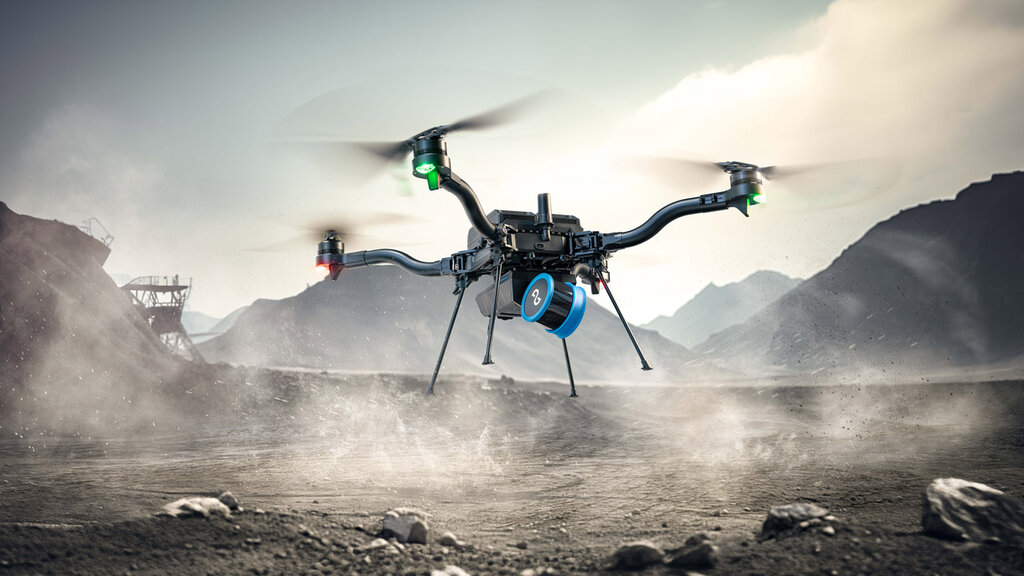
At the heart of Emesent's success lies its flagship product, Hovermap — a cutting-edge mobile scanning unit designed with versatility in mind. Hovermap seamlessly transitions between various operational platforms, from handheld to drone-mounted, vehicle or ground robot-mounted to tethered, catering to the diverse needs of its users with ease.

Send in Hovermap mounted to Boston Dynamics Spot robot to map confined and dangerous spaces, while keeping personnel safe.
Hovermap’s advanced autonomy enables the autonomous mapping of inaccessible and dangerous environments, opening doors to new frontiers of exploration while mitigating risk and saving valuable time. Using Hovermap, mining companies can explore, map, and collect vital information from areas once deemed too hazardous or impractical to access.
Using advanced LiDAR technology, coupled with state-of-the-art algorithms, Hovermap empowers users to navigate hazardous and GPS-denied environments confidently and precisely. Whether mapping small or large domains, from underground caverns or surveying harsh terrains, to inspection and mapping of above ground infrastructure, Hovermap delivers fast and accurate survey-grade point cloud data, enhancing site safety and operational continuity in ways previously thought impossible.
Hovermap can be deployed on a drone to provide autonomous mapping in stopes and vertical shafts, convergence monitoring in drifts, evaluation of new blast designs, and an accurate, up-to-date picture of inaccessible areas. It can also be used as a vehicle-mounted scanner to capture drives, or lowered down raises and ore passes in a cage. Now extending to other applications in mining, including capturing Digital Twins, Hovermap is essential to providing operational insights at some of the biggest mines worldwide.
The capabilities of Hovermap also shine in above ground mining applications, including:
- Inspection and mapping of infrastructure: Gaining detailed insights so operations teams can find, reduce, and avoid production disruptions.
- Stockpiles: Using LiDAR and 3D mapping of stockpiles to make volume estimates, and reconciling data with your other measurement systems.
- Open Cut Mine Mapping: Scanning benches, high walls, and haulage roads for gradients, erosion, and stability.
With a range of up to 300 meters and exceptional dust filtering capabilities, Hovermap accelerates time to insight.
In-field Performance
Hovermap is more than just a technological marvel — it's a game-changer. From Swedish mining giant LKAB to industry leaders like BHP, Hovermap has earned acclaim for its unparalleled performance and reliability in the field, setting new standards of excellence in LiDAR mapping and autonomous exploration.
Traditional cavity monitoring systems (CMS) scans, which could take hours to complete and often yielded poor-quality results, have been replaced by Hovermap's rapid and precise scanning capabilities. What once required days of preparation and coordination can now be accomplished in a matter of minutes, enhancing efficiency and reducing operational downtime.

The tough, lightweight and weather sealed design makes Hovermap equally capable in harsh conditions above ground or underground.
The impact of Hovermap is quantifiable and impressive. Hovermap has played a crucial role in de-risking mining operations at our clients’ sites by enabling them to scan stopes regularly, identifying potential problems, and uncovering new detail, including areas previously hidden by shadows. This proactive approach has significantly reduced the likelihood of production delays and financial losses due to unforeseen issues.
In metalliferous mines, Hovermap has proven invaluable across multiple operational areas. BHP's Olympic Dam mine, for instance, utilized Hovermap to capture accurate point cloud data of stopes, drives, ore passes, and decommissioned infrastructure, enabling geotechnical and engineering teams to optimize stope design and ore recovery, thereby reducing dilution, and improving mining efficiency.
As we look to the future, Emesent remains committed to pushing the boundaries of innovation and redefining the possibilities of autonomous technology. With Hovermap leading the way, the journey towards safer, more efficient mining practices has accelerated. Emesent is here to help clients chart new territories and continue to unlock the vast potential of the world’s mineral and energy resources.
Contact information
Head Office
40-52 McDougall Street,
Kings Row Office Park
Level G, Building 4
Milton, Queensland, 4064, Australia
PO Box: 1401 Milton QLD 4064
Tel.: +61 7 3548 9494
Europe Office
483 Green Lanes
London N13 4BS
United Kingdom
Tel.: +44 7551 534359
North American Office
9200 E. Mineral Ave. #100
Centennial, CO 80112
Web: www.emesent.com