Realise the full potential of your 3D data
X10-GEO
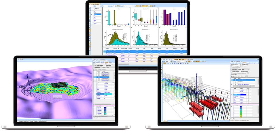
Drill Hole and Block Model Data Analysis
X10-Geo is a high-performance data analysis, visualisation and reporting platform built for geo and data scientists. Used worldwide, by major mining companies and consultancies, it is an essential tool for realising the value hidden in your drill hole, chemical, block model and other spatial data. From exploration to resource estimation and optimization to mine planning, X10-Geo delivers increased productivity and allows for better-informed decision making.


info@phinarsoftware.com
LV1, 16 Ord St,
West Perth, WA 6005, Aus
+61 (0) 424 572 887
BENEFITS
- Save hours, even days on analysing and reporting your drill hole, chemical and block model data.
- Deepen your understanding of your valuable geological data and provide a higher level of confidence in the interpretation you provide.
- Make better decisions throughout the Mine Value chain.
- Significantly increase efficiency by creating your own customised workflows or standardised corporate workflows across the company.
- Integrate your favourite tools.
- Low cost of ownership compared to other mining software packages
- Renowned support helping clients to find the best solutions.
"X10-Geo saves me lots of time reviewing resource models before optimisation."
Nick Gardner. Mine Planning, Kinross
Start your free trial now!
LV1, 16 Ord St,
West Perth, WA 6005, Aus
+61 (0) 424 572 887
CAPABILITIES
- Seamlessly import, analyse and compare multiple data sets like drill hole, point, surface and block models from a variety of data sources and formats into a single project.
- Produce summary statistics and highly interactive graphs in a fraction of the time it takes other packages.
- The fully integrated and dynamic 3D viewer gives immediate feedback on any associated spatial trends.
- Compare spatially related data sets like historic drill holes with their twin, or multiple block models.
- Your graphs, statistics and 3D views are automatically updated as data is added or selected.
- Find and analyse outliers, anomalies and spatial trends with dynamic sliders and graphical data selection tools.
- Share any number of high quality auto-formatted graphs, that can be automatically inserted at specified positions into final reports or summary documents.
"X10-Geo has become an indispensable tool for our Mineral Resource Estimation."
Joe Hirst, Resource Geologist, Tetra Tech, UK
Start your free trial now!
X10-GEO
LV1, 16 Ord St,
West Perth, WA 6005, Aus
+61 (0) 424 572 887
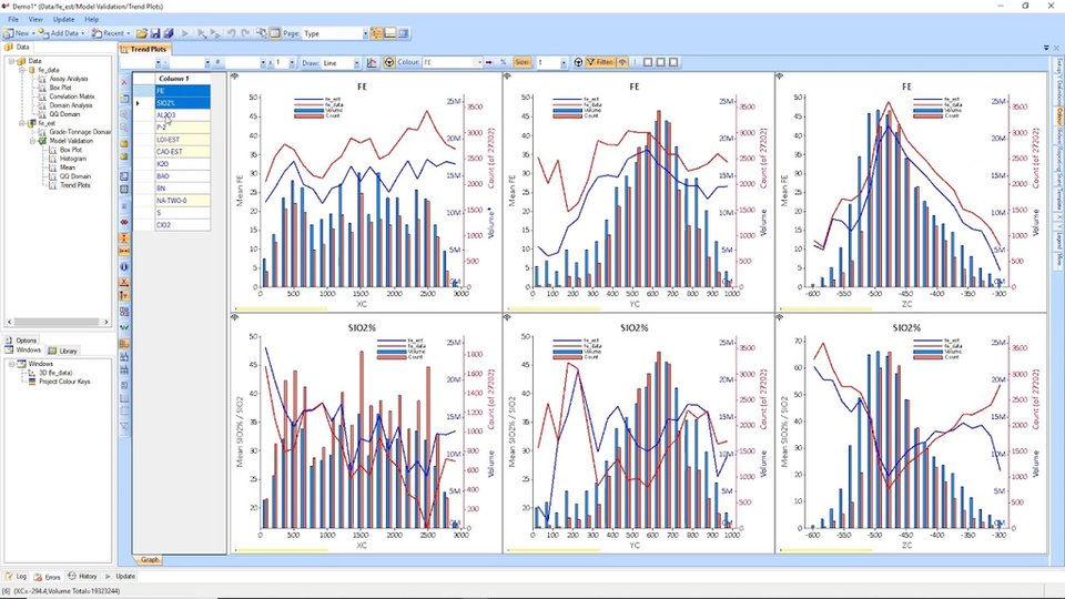
DRILL HOLE DATA ANALYSIS
As well as the generic 3D Exploratory Data Analysis functionality in X10-Geo, the Drill Hole Data analysis module contains industry leading 3D integrated tools such as:
- Contact/boundary analysis
- Twin hole analysis
- Model validation
- Top cut analysis
- Drill hole log
“Your software is brilliant. X10-Geo is the first software in my 12 years in the industry that matches my expectations when it comes to statistics of Geological
and other 3D data.”
Praveen Mishra, Associate Senior Geologist, RPA Canada
Start your free trial now!
X10-GEO