Company Insight
Sponsored by Onirik World Group
Integrated Electro-resonance Remote and Field Sensing
Case Study for Mineral & Water Exploration
There have been notable paradigm shifts in the history of mining. For example, the transition from manual labour to mechanisation, use of remote sensing and geological mapping, open pit mining, automation, and digitisation. These paradigm shifts have transformed the mining industry, improved productivity, safety, and sustainability while expanding the reach and scope of mineral extraction. We believe the electromagnetic frequency-resonance technology and exploration methods are the next paradigm shift for remote and field mineral, oil and gas exploration.
Case study background

This case study outlines the application by a mining company of Mineral Finder technology (MFT) and Water Finder Technology (WFT) to review assets in a gold mine in Latin America. Over the previous 24 years, mine owners had invested hundreds of millions of dollars geophysical field work, and drilling, which had discovered 22 million certified ounces of gold, but they had not delimited the deposit, nor defined underground water.
The MFT study area was eight (8) square kilometres, and the WFT study area was 86 square kilometres. The studies gathered information to support the Environmental and Social Impact Assessment report to be submitted to the environmental regulatory authority.
The MFT exploration goals were to corroborate the data provided by the previous owner, find new gold reserves, and verify mineral reserves were outside the nearby environmentally sensitive area. The WFT exploration goals were to build a model of aquifers to demonstrate that the project was not a threat to the underground water flows and reservoirs that supported the ecosystem and human settlements.
MFT was chosen for the task to reduce the exploration time, the risk, and the investment. Among the other reasons were, the large size of the water study area, the mountainous terrain, the local community had denied field access to 30% of the study area, the technology's successful track record, and that it could complete in a short three-month time frame.
The exploration works began in August 2020 and ended in October.
Case study story and outcomes
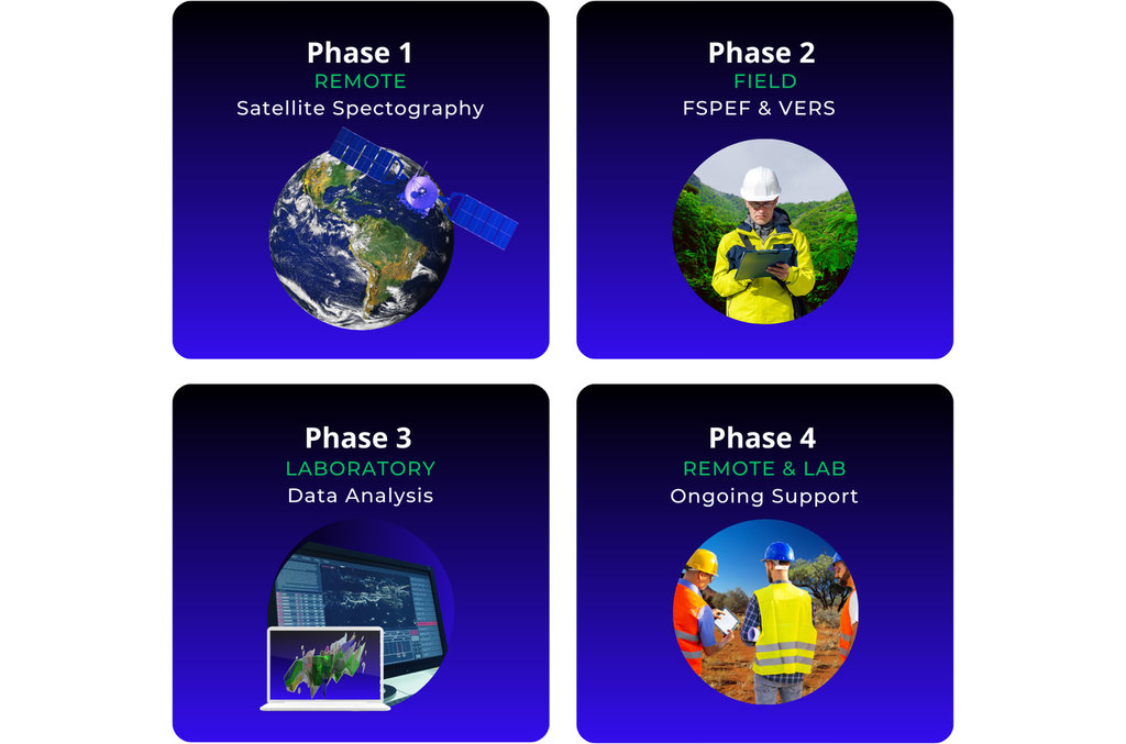
Phase 1 involved analysis of satellite spectrography data, to examine large areas, and identify subsurface geology, minerals, and water. The MFT study identified more than 50 zones with gold, silver, and copper mineralisation. The results were consistent with, and significantly augmented, the client’s existing structural model. The MFT study identified three new areas of gold mineralisation, with a total area of more than 50 hectares, and more than 10 million ounces of new reserves of gold (a 50% increase on known reserves). The WFT study located several underground, continuous flow, aquifers, and most were positioned separately from the mineral reserves.
Phase 2 involves collection and analysis of field data from FSPEF and VERS and improves precision by 10 times. The surveys explored to a depth of 3,100 metres confirming the gold deposits ranged from a depth of 30 metres to depths of up to 2,900 metres.
The MFT study verified that the larger commercially viable reserves were well separated from the surrounding sensitive ecosystem. It also verified that the three new mineralisation zones were close to an existing proven area in production. Phase 2 provided information to support a mine design that would satisfy environmental protection laws.
The WFT study confirmed that the most interesting, mineralised areas were located apart from the water aquifers and only a few mineralisation zones intersected the aquifers. Because the aquifers were water flows, they could be managed with a mine plan that would prevent impact and the water system.
Phase 3 was completed in the laboratory, where the software algorithms processed and integrated the data from the different phases and sources. The output was an accurate three-dimensional map, including reserve location, depth, volumes, grades, valuations, and aquifer flows. Comparing the MFT maps with the historic drilling data, confirmed the correlation was excellent. The combined MFT & WFT report provided the client the data required to complete their environmental submission.
The MFT project investment was less than USD$3M. Subsequent drilling results verified the reserves identified at 94% accuracy. The combined MFT and WFT programs delivered an estimated 95% time saving to certification compared to traditional methods.

Conclusion
Over the last 20 years, around the world, hundreds of successful research and commercial projects have been carried out with MFT. The projects have proven integrated satellite and field electromagnetic frequency-resonance methods solve several exploration digital information confidence challenges for mining.
Get in touch with Onirik for more information
Onirik partners with CTAC to deploy MFT, an exploration service and technology that slashes exploration time and costs, improves data precision and confidence, has no environmental footprint, and significantly improves success rates.
Contact information
Onirik World Group
Level 6, 200 Adelaide Street,
Brisbane QLD, 4000,
Australia
Email: info@onirik.com.au
Web: www.onirik.com.au/mft