TAILINGS
Eyes in the sky: can satellite radar imaging help stop tailings
dam failures?
Research by the University of Nottingham and Terra Motion using advanced satellite radar imaging concludes that the 2019 Brumadinho dam disaster could have been predicted. Julian Turner talks to Geospatial Insight, the company behind a new solution based on the research.
O
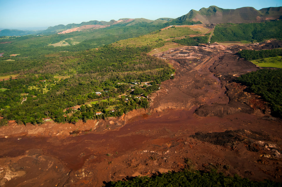
n 25 January 2019, a tailings dam at the Córrego do Feijão iron ore mine, 9km east of Brumadinho in south-eastern Brazil, collapsed, unleashing a mud flow that engulfed a staff canteen, offices and farms. An alarm installed by the mine’s owner Vale in the nearby town of Córrego do Feijão failed to sound. The village was destroyed and 270 people died. It remains Brazil's worst industrial accident.
Two years on, local communities will receive a $7bn (£5.1bn) payout in compensation. Vale also faces additional expenses of £2.68bn related to an agreement to “fully compensate” for the tragedy.
It was not the first time the Brazilian multinational had been linked to a dam disaster in the area. In November 2015, a mining dam operated by subsidiary Samarco collapsed in the town of Mariana, just 120km away in the same state of Minas Gerais, killing 19 people and devastating two villages.
Could the Brumadinho disaster have been prevented? Research from the University of Nottingham and environmental monitoring specialist Terra Motion, using an advanced interferometric synthetic aperture radar (InSAR) technique known as intermittent small baseline subset, concludes that the dam collapse could have been predicted based on ground movements in the weeks prior to the incident.
“By studying the observed movement, we found that different parts of the Brumadinho dam were moving at different rates, some of which accelerated during the two months prior to collapse,” says assistant professor Stephen Grebby from the Nottingham Geospatial Institute, who was the lead author of the study.
“Analysing the velocities at which these areas were moving and how they changed over time then enabled us to predict the possible time of failure.
“In this case, we found that if the dam was being systematically monitored using our technique, the failure date could have been predicted to within a week of it happening. Crucially, this prediction would have been possible around 40 days prior to the collapse, allowing time for a warning to be raised that the dam was becoming unstable.”
A smart solution: MotionMonitor-TSF explained
Now, the research conducted by Nottingham University, Durham University, and Terra Motion has a real-world application, in the form of MotionMonitor-TSF.
Launched by Geospatial Insight – a UK-based provider of risk and business intelligence – the service combines multiple data sources, including satellite data, with artificial intelligence algorithms in order to monitor ground movements in and around tailings dams and provide early warnings of potential structural failures.
“MotionMonitor-TSF, developed in collaboration with Terra Motion and Nottingham University, monitors and highlights ground movement around tailings dams, beaches, and the surrounding slopes to identify movement that could lead to dam failure,” says Geospatial Insight CEO Dave Fox.
“Clients receive their data through an intuitive cloud-based platform, where they can interact with it in a visually engaging format, and by analysing this data are able to decipher any high-risk areas and prioritise appropriate responses.”
Tailings dams are built gradually and get higher as more tailings are stored behind them.

Once the rate of settlement accelerates, the risk is then of failure and collapse.
Once complete, tailings dams continue to settle. Monitoring this is crucial, as any change in the rate of settlement can be a warning sign of potential issues. Another potential risk is that tailings dams can become unstable and leak if the mine waste behind the dam becomes too wet, as Fox explains.
“Dams will naturally rise and fall in response to rainfall and this needs to be taken into account when monitoring the settlement,” he says. “Once the rate of settlement accelerates, the risk is then of failure and collapse. Many tailings storage facilities (TSFs) are no longer operational and monitoring these is crucial to detect any major changes that could indicate risk of failure.
“The subsidence that leads to failure can occur anywhere on the dam or the beach so monitoring the whole TSF, including the dam, the beach, and the surrounding area is therefore important.”
A research paper published in ScienceDirect into the possible causes of the collapse of the tailings dam at Brumadinho claims that vertical subsidence was observed several months before the dam collapse, and that large-scale liquefaction was already happening across the fill before it collapsed.
The benefits of advanced satellite radar imaging
According to Fox, monitoring of motion requires a holistic approach that utilises both ground and earth observation methods. Neither can solve the issue on their own, partly because of the costs.
“Conventional InSAR cannot monitor across the whole facility in vegetated areas as it requires reflective services or ground reflectors, which are generally costly to maintain,” he explains.
APSIS can provide full coverage and detect movements with millimetric accuracy across the entire structure.
“The APSIS InSAR processing technique gives full coverage, however, including heavily vegetated areas where many of these TSFs reside, and of course the earth dams themselves. Monitoring TSFs can become expensive using a range of ground sensors and conventional satellite InSAR methods.
"APSIS can provide full coverage and detect movements with millimetric accuracy across the entire structure, and does so using Sentinel 1 satellite radar data, thereby significantly reducing the cost.
“The method of rapidly identifying surface movement rate changes and anomalies is crucial, providing critical information at an early stage that allows TSF operators to trigger more detailed surveys and remedial actions,” Fox adds.
Can InSAR be used to predict future dam failures?
By mapping ground deformation using radar images from orbiting satellites, MotionMonitor-TSF can identify subtle changes and deliver ongoing monitoring and a regular (up to every six days) ground movement “health check” for TSF structures, as well as early warning alerts of potential failures.
“Data from observations made over several years can form a precise map of land surface changes over a select period,” Fox explains. “These changes may otherwise go undetected and having the ability to identify these risks early allows the client to take appropriate action to minimise the damage that could occur.”
Barriers to the wider uptake of InSAR in mining include the fact that satellite data must be processed using sophisticated algorithms to obtain ground motion data, something companies are not typically able to do in-house. Once they have the ground motion data, they then have to know how to interpret the observed motion in terms of the risk of failure.
Data from observations made over several years can form a precise map of land surface changes over a select period.
Grebby, however, is optimistic, tellingMining Technology in February: “It is clear that this InSAR approach provides complementary information to that which can be obtained using the standard ground-based sensors and monitoring techniques. We therefore hope that the mining sector views this technique as a valuable addition to the monitoring toolbox to help avert similar disasters in the future.
“I think the key to increasing the uptake is to try to provide the necessary information in a form that is user-friendly, perhaps as some form of automated early warning service that can predict the risk of imminent collapse. This is something that our team is now turning our attention to.”

// Main image: The aftermath of the Brumadinho dam collapse. Credit: ILANA LANSKY / Shutterstock.com